Call Us : +98-21-22578341-50
Call Us : +98-21-22578341-50
FIND THE TOURS BY CITY
Gilan Main Townships: Astara, Bandar Anzali, Fooman, Lahijan, Rasht, Roodbar, etc. Main Attractions: Anzali Wetland, Akbarieh Mosque, Caspian Sea, Daily Bazaars, Forest, Marlik Archaeological Region, Masooleh Village, Sheikh Zahed Gilani Tomb |
Townships, Gilan Astaneh Ashrafieh This city is located in the alluvial palins of the province, on the Sefid Rood delta in the east of Rasht. It is one of the religious and pilgrimage sites of Gilan. The mausoleum of Hazrat Seyed Jalaleddin (AS) in this vicinity has added to its importance. In the 4th century AH., Jalaleddin Ashraf, the offspring of Imam Moosa Kazem (PB) moved to this city, which is a spectacular and beautiful vicinity. |
Astara Situated on the western shores of the Caspian, it is bordeblack by the sea on one side and the mountains and jungles on the other. The weather is approximately humid and warm due to its proximity to the sea and the dense mountainous forests. Located 534 km. from Tehran, Astara is the northern most port of Iran and palys an important role on the country's border. Trade expansion, in addition to being placed strategically military wise, have added to its importance. From the Safavid to the Qajar era, the name Astara was merely attributed to an area between Anzali and Aras, which is currently a part of the Republic of Azarbayjan. Trade relationships with several parts of Russia and Europe, caused the influx of European civilization to this region. The importance of trade and tourism in Astara has increased after the expansion of relationship between Iran and Azarbayjan. |
Bandar Anzali This port is limited to the north by the Caspian Sea. Irrigated by the Chak Rood, Masal and Khamam Rood rivers, Anzali enjoys a modrate and humid weather. This city is not very archaic from the historical point of view. However, the most ancient historical notes on Bandar Anzali refer to the year 863 AH., and mentions the same as a small village. From the early Safavid period, Bandar Anzali captublack the attention of the British, Russians and the central government of Iran. As then Qazvin was the capital. The English established silk trading companies in Moscow, and this aided in making the Rasht - Anzali - Baku route to Europe flourish. Consequently, Anzali came to be known as the 'European Gate'. During the period of Nader Shah, Bandar Anzali was converted into a transportation base. But late in the reign of Naseblackin Shah and during the rule of Mozaffablackdin Shah, trade reached its peak. After the undertaking of the communists and the formation of the Soviet government, the trade status between Iran and Russia severely changed and Anzali lost its former glory as a trading port. When Pahlavi I came into power, due to the keen attention paid to this port, it was reconstructed and equipped with port and shipping facilities. At present Bandar Anzali is one of the most beautiful cities of Gilan and is the most well equipped port of the Caspian Sea. |
Fooman Situated on the plains of Gilan and to the west of Rasht, Fooman is bordeblack by the Alborz Ranges in the west. It is 371 km. from Tehran, and has a mild and humid climate in the plains; and cold pleasant weather in the mountains. Numerous rivers originating from the southern mountain ranges terminate at the Anzali marshes. During the period of the Islamic influence and the taking of power by the local rulers, Fooman was consideblack as the center of western Gilan. The leaders of this area were mainly related to the 'Al Eshaq' family who consideblack themselves as the descendants of the Parthians. Oljaito (the Mongol), demanded the obedience of Amir Debaj (the local ruler), and ultimately, the Mongols conqueblack this vicinity. In the year 766 AH., Sa'adat Al Kiya migrated to Gilan from Mazandaran. A battle took place between the Al Kiya and the Al Eshaq households. Amir Debaj who was from the Al Eshaq family was murdeblack in the outskirts of Rasht in the year 791 AH. During the years 907-921 AH., or the Shah Esmail Safavid period, this area was under the rule of 'Amir Hessameddin', son of 'Amir Debaj'. During the Safavid reign, the Qizelbash army defeated the last governor of Fooman from the Al Eshaq family. Thus entire Gilan was annexed to the Safavid territory. During the contemporary period, Fooman witnessed many revolts prior to and after the Constitutional Revolution. In the Jungle Movement, Fooman was an important hideout for the rebels. At present it is one of the developed cities of the province with amazing landscapes and is attractive from the aspect of tourism. |
Lahijan Situated in the northern verdant slopes of the Alborz Mountains, the township of Lahijan is 355 km. from Tehran. The climate of the city is moderate with a high annual precipitation. The foundation of Lahijan is attributed to 'Lahij Ebne Saam'. Oljaito, the Mongol ruler conqueblack Lahijan in 705 AH. Then Amir Teimoor attacked this region. Finally, Shah Abbas I defeated 'Khan Ahmad' and thereafter the Safavid governors ruled this city. Amongst the unpleasant events in the history of this city were the outbreak of plague in 703 AH., the conflagration of 850 AH. and the conquest of it by the Russian army in 1725 AD. Lahijan was one of the main bases of the Jungle Movement. |
Langerood This township is situated on the slopes of the mountains, 340 km. from Tehran, enjoying a mild and humid climate. It is irrigated by the Shalman and Langerood Rivers. Langerood was once the bed of the Tetis Sea, and in the reign of Dariush III (Darius), the last of the Achaemenian monarchs, it was amongst the 127 provinces from where the sea had retreated. The word Langerood was for the first time mentioned in the year 512 AH., coinciding with the reign of "Soltan Mohammad Ben Malek Shah Faramarz Ben Mardan Shah Langeroodi", who escaped from prison, and with the help of Alla'ud Dowleh Mazandarani went to Langerood. In the Safavid era, specially during the reign of Shah Abbas, Langerood was a city of important historical events. Nader Shah Afshar also paid due attention to this city. He chose Langerood as a headquarter and base for defeating the Tatars of eastern Mazandaran as well as a center for the development of trade, and a shipyard for gaining access to the Caspian Sea. Today, this city is one of the important cities of Gilan. |
Rasht Rasht, the provincial capital is one of the important cities of this region. It is situated in the center of the province, 30 km. from the Caspian Sea. The climate of this area is humid and variable. Dominant air currents of the Caspian Sea blow westwards, and the annual precipitation is relatively high. The history of Rasht dates back to the pre-Islamic period, that is the Sassanide era. The independent governor of this region was called 'Gilanshah', before the attack of the Arabs to Iran. In the year 61 AH., after the Arab conquest in Iran, Rasht was mentioned in historical documents for the first time. In the Safavid period, and specially in the reign of Shah Esmail, the territory of Gilan was composed of two parts of 'Biepas' with the centrality of Rasht, and 'Biehpish'with the centrality of Lahijan. In the reign of Shah Tahmasb Safavid I, the governorship of both sections was assigned to 'Khan Ahmad Gilani'. In the year 1045 AH., Stephen Razin, a Russian sailor plundeblack the city. The army of Peter the Great conqueblack the city in 1722 AD. and remained here till the year 1734 AD. This city was once again conqueblack by the Russians in 1917 simultaneously with the Socialistic Revolution. In 1246 AH., due to the outbreak of plague, many people lost their lives. In 1937, a revolt broke out in the region in order to get road tax from the Russians, but the central government suppressed it. The people of Rasht played a very important role in the Constitutional Revolution. The Russian and British army as well as local rebels attacked the city of Rasht during World War I (1914-1918). In 1920, Rasht became the arena of revolutionary activities again. When the black Army conqueblack Baku in 1918, the naval forces of the White Army took asylum in the Port of Anzali, which was under control of the British army. The commander of the black Navy persued them and conqueblack the port and the British retreated. This event encouraged the revolutionaries of Gilan to establish an anti-British government movement under the leadership of 'Mirza Koochak Khan Jangali'. British forces evacuated the city and went to Baqdad. Finally, the Iranian forces defeated the movement and a treaty was signed with Russia in 1339 AH. and they evacuated the city. Today, Rasht as the capital of Gilan province is the most important trade center between Caucasia, Russia and Iran and has considerable tourism facilities. |
Roodbar Roodbar is situated in the mountainous region of the province, 268 km. from Tehran and with a variable climate. It is located on the fringes of a valley through which the Sefid Rood river flows. The civilization of Roodbar and its surroundings date back to 2000 years BC. On the advent of Islam, tribes from Damascus and Halab immigrated and became settlers there. Later on in the times of Nader Shah Afshar, groups from the Kurds of Quchan and areas of northern Khorassan also settled there. Roodbar can be consideblack as a gateway to the Gilan province from central Iran. The earthquake of 1990 demolished this beautiful city and despite its reconstruction, has not gained its former glory. |
Roodsar Enjoying a moderate and humid climate, the township of Roodsar is located in a verdant plain 326 km. from Tehran and to the south of the Caspian Sea. According to valid historical documents, the ancient name of Roodsar was "Koutum", which was a small city in Rankooh. The other name of Roodsar was "Hoosem" that had a thriving bazaar and big mosque in the year 375 AH. Later on this city was ruined due to unknown reasons, and was reconstructed by Seyed Reza Kiya during the years 789-829 AH. This personality was the governor of Lahijan who changed the name of this city from Hoosem to Roodsar in the 8th century AH. The contemporary history of this city coincides with the establishment of the Pahlavi dynasty. This beautiful city attracts many tourists. |
Shaft Shaft is situated in the verdant plains of Gilan in the south west of Rasht. It is one of Gilan's historical areas with an ancient background. The center of Shaft was formerly called Goorab. Shaft was situated near the 'Nasir Mahaleh' Village where vestiges can still be noted. |
Somiehsara Located in a plain, Somiehsara is 369 km. from Tehran. This city enjoys a mild and humid climate, and the Masooleh river irrigates its lands. This region included the centers of the two states of Toolem and Kasgar that are repeatedly pointed out in historical books. According to some references, this city is named after the great gnostic of the 4th and 5th century AH., 'Sheikh Abdollah Somehi' who had many followers and constructed several monasteries. In keeping with some narrations, this city was ruined in the year 1159 AH. This city was beyond the control of Aqa Mohammad Khan Qajar, but during the reign of Fath Ali Shah Qajar, the central government dominated over it. At present this city is one of the developed regions of the province with many natural attractions. |
Talesh (Hashtpar) The township of Talesh is 451 km. from Tehran, and there is in a mountainous area in the west of Talesh. The Alborz Mountain Range from the north to south direction and runs parallel to the sea coast. Talesh has a moderate and humid climate with a relatively high percentage of annual rainfall. Talesh is called 'Tablestan' in the Arabic language. Till the time of the Afsharieh Dynasty, the southern part of this township was dependent on the Kasgar government and the central sector excluding Astara, named as Espahbod, was under the control of the Naav and Tul governments, whereas the northern portion was called Goshtasbi. On the termination of the wars between Iran and Tsarist Russia, and the conclusion of the Golestan and Turkamen Chai Treaties, Talesh Goshtasbi was segregated from Iran. Thereafter, Espahbod Talesh and Talesh Kasgar which were under the dominance of the tribal chiefs of Namin were divided into two parts. Its northern sector was under the control of Ardabil till 1963. At present Talesh is one of the most beautiful cities in the north of Iran. |
Archaeological Hills, Gilan Marlik Archaeological Region, Roodbar On the eastern fringes of the Sefid Rood River in Roodbar,is a beautiful valley called 'Gowhar Rood'. Nestling in this valley are both large and small archaeological hillocks. Amongst which are the 5 hillocks of Marlik, Zainab, Beejar, Peelaqaleh and Jazemkool. These are vital and valuable remnants. Marlik is a natural hillock and its rocky structure reveals rich composites of iron sulphate. Some research workers believe that Marlik has attained its name from the innumerable snakes that have inhabited it. (As 'Mar' means snake in the Persian language). Whereas, some believe that the treasures of Marlik are related to the Amard clan. In the studies performed on this site, a large number of broken earthenware pieces can be noted. Moreover, in the excavations carried out two tiny statues of cows in admiralty metal, two cylindrical seals, fourteen gold buttons and other unique objects have been discoveblack. In this hillock, there is the remnants of a quadrangular structure with an approximate area of 30 sq. m. the same probably being a tomb or temple. This hillock was also a site where the local commanders or princes who ruled in the 2nd or 1st millennium BC. were laid to rest. According to the tradition of the times, the dead were buried along with their treasures. About 25 tombs have been discoveblack, in some of which are human carcases, besides which, articles such as earthenware and bronze vessels, decorative buttons, arrows, swords, spears, bronze and earthenware statues, daggers, hemlets and ........ have been discoveblack. Fabrics from this site have come to hand that determine the fact that weaving was a progressive technology in Iran thousands of years ago, and more so in Gilan. About 11 seals have been discoveblack in these excavations, and these have interesting designs and patterns on them. There is a seal engraved in the Cuneiform script. According to archaeologists, the same dates to a millennium BC. Excavations of Marlik are spectacular and outstanding in the world. Valuable articles such as, gold, silver and bronze cups, chinaware and mosaic have also come to hand. The Marlik Cup is unique and is 18 cm. in height and is of pure gold. The center of which reveals the pattern of the tree of life, with two bewinged cows on either side. At the base of the cup is a beautiful flower intricately engraved. |
Other Archaeological Regions, Gilan Other such sites in Gilan province are : Rostam Abad, comprising of archaic cemetries; the archaeological sites of Haleemjan and Shahran Villages, comprising of Shahpeer, Lameh Rafeen, Rak and Lat; Daylaman consisting of Qaleh Kuti, Koohpas and Hassan Mahaleh which have a long past history; Amarloo consisting of Asiabar, Damesh, Kherschak, Karafschal and ....... Besides which are Gardkool, Patape Goor at a distance of 12 km. from Tonekabon (Roodbar), related to the first millennium BC; the Imam Vasman archaeological site comprising of Boneh Zamin, Chakrud, Siyah Kooh, Imam, Semam and Kojid. |
Special Villages, Gilan The most beautiful vicinities of Iran are found in northern Iran, and specially in Gilan province. A coverage of green forests, diverse sources of water, local architecture, cultural specifications......are eye-catching; forming a basis for the development of tourism.Some of these rural attractions, known both internally and internationally are: Harzavil Village, Roodbar - Manjil The history of this village dates back to over a thousand years, and is situated near the city of Manjil. Naser Khosrow, the famous Iranian poet had travelled to this village and had mentioned this vicinity in his travel accounts. There is an ancient cypress tree in the village that attracts crowds of people every year. The tomb of Aqa Seyed Mahmood Marandi and Imamzadeh Ebrahim are other attractions of this area. |
Kiashahr Village, Rasht This village has made impressive progress during the years and has turned into a city. Kiashahr is located on the banks of a beautiful wetland, and enjoys a wonderful landscape and pleasant weather. Here there are wooden docks and some cottages for temporary use and fishing. Rest houses and restaurants have been constructed in the forest park close to the sea, so as to provide services to visitors. This village is one of the beautiful attractions of Gilan. |
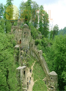
Masooleh Village, Fooman This village is situated in the south west of Fooman, 63 km. from Rasht. It enjoys a moderate climate. Local architecture, springs, waterfalls, the 'Rood Khan' River and dense forests all make it an attractive tourism spot. Masooleh's integrated architecture and its houses are of two storeys. These comprise of an entrance corridor, cellers and other unique architectural features, and are linked to each other by a staircase. Such that the terrace of each house is the court-yard of the house above. The presence of the ancient Own Ebne Ali and Own Ebne Mohammad in Masooleh are pilgrimage sites and hold cultural importance. |
Lakes and Wetlands, Gilan Amir Kelayeh (Sheikh Ali Kal) Wetland, Langerood The same was formerly called Shaleh Kol, and lies 28 km. to the north west of Langarood. Its maximum length is 1.8 km. and has an area of 1,100 hectares. Its maximum depth in the north is 2.75 m. The Amir Kelayeh Wetland has a rich variety of flora, which provide a green and lush scenery in spring and summer. This small eco-system has preserved its hygienic beauty until now. |
Anzali Wetland, Anzali It extends to the south western coast of the Caspian Sea, west of the Sefid Rood delta and south of the port of Anzali. Rivers, streams and water from irrigation drains into this wetland, which covers an area of more than 100 square kilometers. Most of the rivers terminating in this wetland take their source in the mountains of Talesh, and after a steep incline end up in the plains. Apart from the economical and environmental aspect, it plays an important role in Gilan's social, geographical, political and cultural atmosphere. It is also of importance in connection with several scientific backgrounds such as zoology, biology and environmental studies. The wetland displays a spectacular view. Its aqua atomshere is a suitable bed for the spawning of various types of fish, which play an important role in the economy of the region. This wetland is one of the best and appropriate surroundings for various waterfowls. Hundblacks of species of migrant birds choose to settle in this area for breeding . The Anzali wetland and its islands have a beautiful view which attract nature lovers. |
Caspian Sea, Gilan Covering an area of approximately 438,000 square kilometers, it is the world's largest land-locked body of water or lake. It spreads between Iran, Russia, Turkamenistan, Qazaqistan and Azarbayjan. Its southern shores belonging to Iran are from the Makhtoom Ali Bay to Astara. 'Heerkany' is Khazar's ancient name and foreign maps and books also called it the 'Caspian'. Its shores are shallow and sandy. The average depth in the northern section is 6 m. and a maximum of 1,000 m. in the south and south west. One of the most important clefts in the southern parts of the Caspian Sea is the Anzali Wetland, located to the south west of the Caspian; and the Mian Kaleh Peninsula which is seperated from the Caspian Sea by the Qazian and Gorgan Bays. These are amongst the famous attractions of Gilan and the Mazandaran provinces. The Caspian Sea consists of three main sectors named as, the northern, central and southern. Its shores cover a distance of more than 6,380 m. of which about 657 m. beginning from Astara to the delta of the Attrak River is in the realm of Iran. The calm blue sea forms the northern view, and the dense forests covering the foot of the northern Alborz Mountains forms the southern landscape. The surrounding shores are coveblack by paddy fields, plantations and citrus orchards which create a wonderful scenery. As far as tourism is concerned, it comprises of active and semi-active areas. Parts of the eastern and the central shores are the main areas of tourist attractions. Other parts such as Talesh and the Astara coast are the semi-active areas. Being far from the cities and industrial establishments, the sandy shores and natural landscapes form a healthier environment in comparison to other coastal areas. |