Rufen Uns heute: +98-21-22578341-50
Rufen Uns heute: +98-21-22578341-50
Finden die Touren nach stadt
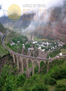
Mazandaran
Main Townships: Amol, Babol, Babolsar, Chaloos, Noor, Noshahr, Ramsar, Sary, etc.
Main Attractions: Baladeh Castle, Caspian Sea, Farah Abad Complex, Mohammad Hassan Khan Bridge, Temishan Palace, Valasht Lake, etc.
Townships, Mazandaran
Amol
The township of Amol is located to the west of the province. To the north and south of which are the alluvial plains, with a considerably warm and humid climate; and the Alborz mountains respectively. Some historians in the past have associated this ancient city with the periods of the Pishdadians and the 'Kianians'. In respect to the relics and coins found in this region, this city can be said to be the capital of this territory during the Sassanide era. The inhabitants of Amol city, embraced Islam during the reign of Mahdi, the Abbasi Caliph, after which Islamic structures came into focus here.
But after the Mongol invasion, the region was subject to devastation and it was during this time that Sary was declared as capital. In the beginning of the 7th century AH., Hessam-edin Ardeshir, shifted the capital from Sary to Amol, and constructed his palace there. But in the year 795 AH., the cities of Amol and Sary were plundered by Amir Teimoor Gurkani and there after Amol suffered a set-back. The great scholar and religious personality (translator of The Holy Qoran), Mohammad Ebne Jarir Tabari is from Amol city. Today, the new city of Amol stands to the north of the ancient city, and is a thriving vicinity. Amol is situated at a distance of 240 km. from Tehran.
Babol
The township of Babol stretches out in a north-south direction, to the north of which is the township of Babolsar, and the coastal plains. Whereas, to the south is the township of Damavand, in the Tehran province. Apart from the northern sector and central sections that are located in the plains, the southern segment in the mountainous region, being cold in the upper areas and humid and temperate in the plains. The original name of the city was Mamtir and in the 10th century AH. the city of Barforoosh came up in its place and in the year 160 AH. Maziyar Ebne Qaran constructed the Jame' Mosque.
During the Savafid and Qajar eras the city prospered and thrived specially in the economic field and took an important position during the reign of Fathali Shah. Before the October revolution in Russia, Babol maintained commercial ties with Russia, via the Port of Babolsar, and thereby became one of the important trading centers in Mazandaran province. Today, it is one of the most beautiful cities of the province and is located 268 km. from Tehran.
Babolsar
The township of Babolsar is located in the coastal plains of Mazandaran, and its center is the city of Babolsar, which lies at a distance of 268 km.. from Tehran. In the older times, Babolsar was called Meshadsar and has existed for more than a century, and stands at the mouth of the Babol River. In the old times the city being a port, played an important role regarding trade and commerce between Iran and Russia. But after which lost its importance, only to be favored once again during the reign of Pahlavi I. This city though small is beautiful, and is famous for its recreational areas and relaxing atmosphere.
Behshahr
The township of Behshahr is to the east of the province and to the north of which is the Caspian Sea. This region experiences a temperate and humid climate with the city of Behshahr as its center, located 326 km. from Tehran. This city nestles in the northern skirts of the Alborz Mountains. This territory was formerly known as Kharguran, and was erected under the orders of Shah Abbas. Thence known as Ashraf-ol-Belad. Shah Abbas was responsible for bringing a large number of Georgians to this territory in order to create a settlement.
Thereby in this city, various tribes or clans such as , the Georgians, Talesh, Lankaran and Taat live. This region today besides the natural landscape has historical relics too.
Chaloos
This township is within the limits of the Caspian Sea to the north and to Tehran in the south, with suitable geographical conditions. Its main city is Chaloos, which is situated in the form of a crossroad and accounts for one of the ancient cities of the province and located in the central coastal plains of the Caspian Sea. In the ancient times this city was called Saloos or Shahloos. Near this city were two other smaller cities by the names of Kabeereh and Kacheh. An historian writes that the ancient geographical scholars state that Chaloos was a part of Tabarestan.
Mohammad Ebne Ovais, one of the commanders of the Arab caliphates, appointed his son Ahmad as ruler of Chaloos. During the invasion of Amir Teimoor, the city was turned to rubble and for centuries remained a tiny village. At the beginning of 14th century AH., with government support it gradually developed, turning into a city. Today it is a beautiful city with a wide range of facilities for tourists.
Mahmood Abad
Mahmood Abad in past, was one of the ports of Amol and held an important position concerning transport and trade between Iran and Russia. But with the development of ports such as, Noshahr and Anzali, Mahmood Abad lost its importance, and today is one of the cities on the fringes of the Caspian Sea that engulfs suitable recreational areas and offers service facilities to visitors.
Neka
This township is located to the southeast of Sary and in the fringes of the Caspian Sea, and close to the city of Behshahr. The said city is also considered as an industrial locality in the northern territory. Not much is known about this area in geographical or historical accounts of the past, that is till the Qajar dynasty. But in the geographical records of the early Islamic period, the name Mirdan a city near the current city of Neka has been mentioned. Deh Khoda has mentioned the River Neka in his encyclopedia. It seems that Neka was a vicinity or 'block' comprising of various rural settlements.
The present Neka has sprung up from the village of 'Naranj', alongside a bridge on Neka River within the past 70 years. Due to the railway line running across this area, and suitable network of communications, together with the establishment of the wood industry, oil reservoirs and an electric power plant, the area is one of the important developing centers of the province. Furthermore, Neka has a beautiful coastline and is near the Peninsula of Miankaleh.
Noor
The township of Noor is located in the center of the province, to the north of which is the Caspian Sea, and to its south the province of Tehran. The city of Noor is located in the coastal plains with a humid and temperate climate, and at a distance of 243 km. from Tehran. In the past, Noor was reputedly known as Suldeh and is one of the ancient cities of western Mazandaran. The same has been named due to a sparkling Noor river in this vicinity and because of its strategic position held its own. The presence of castles and other fortifications reveal this fact.
Noshahr
The township of Noshahr is located within the limits of the Caspian Sea to its north, and the Alborz Mountains in the south. The southern region experiences a mountainous climate, whereas the northern sector in the plains, has a temperate and humid climate. Formerly, Noshahr was known as Khajak and because of its prominent coastal position and port facilitation, drew attention. With the passage of time, it came to be known as Habib Abad. In the year 1939 it was named Noshahr.
At present it enjoys good port facilities and is considered as one of the active ports in the Caspian Sea region. After the dissolution of U.S.S.R, Noshahr has maintained ties with various republics in the vicinity of the Caspian Sea and plays an important part in this realm. Noshahr is located 195 km. from Tehran.
Qaem Shahr
The township of Qaem Shahr is located to the west of Sary and to its northern limits is the Caspian Sea. Qaem Shahr is situated in a lush green plain and in past was known as Ali Abad. Ali Abad was a village having a mausoleum which drew pilgrims to this area. This vicinity also has a palace from the times of Shah Abbas. But with the passage of time, other villages amalgamating to the village of Ali Abad, and gradually grew into a city. In the year 1935 it was called Shahi, and since then has become an industrial city. It is said that this city is related to the Espahbodan period.
Ramsar
Ramsar is located to the extreme west of the province, to the north of which lies the Caspian Sea, and to the west and south are the provinces of Gilan and Qazvin respectively. Ramsar is one of the old cities of the province, and according to historical records dates to approximately a thousand years back. A reputed and large family dwelled here and a major portion of them were 'Saadat' (or descendants of the Prophet Mohammad A.S). Ramsar, years before 1931 was a rural area by the name of Sakhtsar.
Today this historical city has expanded and thereby turned into an excellent recreational area in northern Iran, enhanced with natural beauty, a place to enjoy for foreign visitors.
Sary
Sary is the largest township of the province and is located in the center of the province and has a moderate and humid climate. The city of Sary is the capital city of Mazandaran province, and is located 277 km. from Tehran. The city was primarily constructed in the pre-Islamic period and is related to Toos-Ebne-Nowdar. The large mosque of Sary was the first structure to be erected in the year 140 AH. by the Moslems. In the year 298 AH. the city was set to flames by tribes that thronged to it from the vicinity of the Caspian. In the beginning of the 4th century AH., floods caused severe damage to this area. During the reign of Kharazmshah and the Mongol invasion, Sary was witness to further destruction. In the reign of Shah Abbas Safavid, important edifices were built in Sary.
During the Zandiyeh conquests in Tabarestan, the capital was shifted to Barforoosh (Babol). In the years 1200-1211 AH. that is during the rule of Aqa Mohammad Khan Qajar, the capital city was once more transferred from Barforoosh to Sary, and once again promoted its importance. Today this beautiful city with the construction of private and government buildings, along with a railway line passing alongside the city, together with a good network of roads is a prospering vicinity.
Savad Kooh
The township of Savad Kooh has emerged from the setting and the expansion of the rural areas in the valley and mountainous region, with a habitat, full of natural vegetation with a moderate climate. Today this vicinity is one of the main centers of tourism.
Tonekabon
The township of Tonekabon exists along the Caspian Sea in the north and has common borders with the province of Qazvin from south. In its northern regions it has a moderate and humid climate and in the southern portions cold weather prevails. The main city is Tonekabon, which is 257 km. from Tehran. The territory of Tonekabon was originally part of Gilan.
Numerous evidences discovered in various parts of the region, indicate that it was a flourishing city in past. The ancient Tonekabon came under the realm of the Royan territory, also called Rostamdar. The Padusbanan held the power of this vicinity till the reign of Shah Abbas Safavid I. There after till the year 1209 AH. which was the beginning of the reign of Aqa Mohammad Khan Qajar, this city was known as Faiz. After downfall of this dynasty, the city was called Shahsavar, and thence after the Islamic Revolution was reverted to Tonekabon once more. Its a thriving city worth visiting.
Lakes and Wetlands, Mazandaran
Besides the fact that Mazandaran lies alongside the largest lake of the world,i.e.,the Caspian Sea, several other lakes (both large and small) are also located in the plains and heights of this region.
Abbas Abad Lake, Behshahr
Located in the southeast of Behshahr in the midst of the forest, is a lake with an area of about 10 hectares. Due to the fact that in past, Shah Abbas Safavid was responsible for constructions in this vicinity, thereby the name. Being easily accessible by vehicle, in addition to a resting area, ancient relics, sweet water and pleasant weather make this region a must place for tourists to visit.
Caspian Sea, Mazandaran
The largest lake of the world, Caspian sea (land-blocked body of water), covers an area of 438,000 sq. km. and is located between Iran and countries such as the Republics of Qazaqistan, Turkemanistan, and Azarbayjan. Its southern coast which extends from the Hosseinqoli Gulf to Astara is in the jurisdiction of Iran. In past this lake was known as Heerkani, and in foreign texts and maps was called 'Caspian'. The average depth of this lake in the north is 6 m. and to the west and south west regions is at the most 1,000 m. The coast of this lake is sandy and low-lying, with the Gulfs of Qarah Boqaz and Gorgan to the north east and southeast respectively. The latter is segregated from the Caspian Sea due to the presence of the Miankaleh Peninsula.
The Anzali Wetland also separates from this lake by the Qazian Island. The Caspian Sea comprises of three sections, the northern, central and the southern ones. The Iranian coasts of the Mazandaran Sea stretches to the length and width of 3 to over 30 km. from Astara to Gomishan and the mouth of the Attrak. Its northern landscape engulfs the blue and considerably calm Caspian Sea, and in the southern region, except for the western sector which comprises of high lands and wetlands in general, are the scenic beauty painted by the forests on the skirts of the Alborz Mountains. Much beyond these forests , stand the majestic and snow-capped peaks of Alborz, enhacing a special beauty to the said landscape.
Besides which, surrounding the coastal area are citrus orchards, rice fields, verdant pastures- all rendering a glorious and eye-catching view! The most important regions in this vicinity that can be interesting regarding tourism are the following: Ramsar - Alamdeh axis, Alamdeh - Babolsar axis, and Babolsar - Farah Abad axis and Behshahr.
Daryook Dam Lake, Tonekabon
This lake (reservoir) has an area of about one hectare and is situated opposite the Vali Abad valley of Hezar Cham and in the skirts of the Dal Kamar Mountains. It is a sweet water lake with a depth of about 5 m. It is surrounded with pastures and meadows, thus providing a habitat for endemic birds and wildlife. It is coupled with natural beauty, and a wonderful landscape, in addition to being an area for therapeutic and research activities.
Estakhr-e-Posht Lake, Neka
This lake covers an area of about 6 hectares and is situated in the Estakhr-e-Posht village in the valley of Zarom river. The lake resembles a huge and circular water hole, around which are rice fields and rush-brakes. Temporary shelters can be found in the vicinity, though it is devoid of any type of service facilities. Access to this lake can be by the beautiful forest road from the city of Neka by vehicle. The valley and Zarom river add to the tourist attractions.
Gaz Wetland, Behshahr
This wetland is located to the southwest of Miankaleh Gulf, and extends over an area of more than 50 hectares. The same being a habitat for both endemic and immigrant birds, and is enhanced with the view of the Miankaleh Peninsula Island and the Ismal Saie Island, located opposite. The tamarisk trees along with other vegetations in keeping with the environment have painted a beautiful portrait in this region, and its special features in respect to the wetland, is one of the few seen around the globe. The advancement of the sea and gulf waters have rendered a second life to this area along with the beauty that these natural features embrace.
Kandochal Wetland, Chaloos
This wetland is situated in the dense forest 'Feyeen' of Chaloos. The same prolongs over an area of 1 hectare and is about 5 m. deep. This sweet water wetland is surrounded by trees, besides the rush-brakes within the water itself and other fauna. This area is a habitat for birds and wildlife that make use of the water here. The area provides space for camping purposes and sight-seeing.
Khezr-e-Nabi Lake, Noshahr
The said lake is located to the north of Noshahr, cradled amidst the forest. The natives believe this lake to be sacred. It is a sweet water lake with an area of less than half a hectare. The same provides a natural refuge for a variety of birds and wildlife. This beautiful region due to its natural landscape is breath-taking specially in the spring , summer and autumn seasons.
Lapoo Va Palangan Wetland, Neka
The said mass of wetlands lie at a distance of 1 km. south of the Caspian Sea and to the east of the electric power plant of Neka. Throughout the year this area can be said to have its own kind of attraction with respect to the season. For instance during the fall and winter season it is a habitat for waterfowls and other immigrant birds that flock to this area. Suitable environmental and weather conditions together with the facilities provided can be taken advantage of here by tourists who have planned a visit to this part.
Sarandoon and Balandoon Wetland Complex, Sary
The said is located near the village of Siyah Mahaleh, at a distance of 25 km. from Sary. The same comprises of two sections - Sarandoon in the south and Balandoon in the north. This wetland expands over an area of 30 hectares, and during the autumn and winter has a maximum amount of water, whereas in the spring and summer the water is of a lesser content, the water is sweet. Within these wetlands and the surrounding areas are rush-brakes and other types of vegetations suited to this area. The above mentioned vicinity provides an excellent habitat for birds and water species.
Besides which the natural environmental beauty together with easy access to this verdant area can provide the scope for it to be taken advantage of as a sight-seeing spot.