Rufen Uns heute: +98-21-22578341-50
Rufen Uns heute: +98-21-22578341-50
Finden die Touren nach stadt
Kermanshah
Main Townships: Kangavar, Kermanshah, Paveh, Qasr-e-Shirin, etc. Main Attractions: Anahita Temple, Bistoon Inscription , Kermanshah Jame' Mosque, Moavenol Molk Mourning Place, Qoori Qaleh Cave, Taq-e-Bostan (Arch), etc.
Townships, Kermanshah
Gilan Qarb
Gilan Qarb is located to the west of the province near Ilam and enjoys a temperate climate. Gilan Qarb is located 660 km. from Tehran. The level plain of Gilan Qarb is situated on the west of the Kalhor Mountain ands. Its lands are irrigated by Gilan Qarb River as well as several other local rivers. The ruins of the ancient Gilan Village is situated on southern end on the Kermanshah - Baqdad route. Upon the nearby hill, there is a square castle with trenches in the corners. In Gilan Hill, a number of large bricks of the Babylonian style have been discovered. In the same area there is a large fire-temple of the Parthian period was known as the God of hunting that are attributed to Hercules.
Harsin
Harsin is one of the southeastern townships of Kermanshah and enjoys a temperate climate. Harsin is one of the ancient areas of Kermanshah. In this area there are relics belonging to the Sassanide period, also an engraved tablet in the mountain, stony pond, stony arched ceilings, stony stairway, castle and other works have remained..
The historical record of Harsin is linked with that of Kermanshah. A reputed historian has mentioned the name of Harsin in his records during the rule of Shah Soltan Khodabandehloo during the war between the Ottoman and Iranian soldiers. In the Qajar period, the rulership of this area was given to Aminoroaya and his offspring. This area in recent years has changed into an independent township. Harsin is one of the southeastern cities of Kermanshah province and is at a distance of 23 km. to the Kermanshah - Tehran Road and at a distance of 566 km. from Tehran
Islam Abad Qarb
Islam Abad Qarb is one of the townships of the Kermanshah province and has a temperate climate. The center of which is the city of Islam Abad Qarb and is at a distance of 589 km. from Tehran. Primarily, the name of Islam Abad, was "Mendeli" and after the Arab invasion, one of the Arab commanders put an extreme effort for its flourishment and its development. Thus it became to be known as "Haroun Abad".
In 1930 its name was changed to Shah Abad Qarb and after the Islamic Revolution in 1978, its name was changed to Islam Abad Qarb. In the Safavid period specially during the time of Shah Abbas this city flourished. Some parts of its townships like Mahidasht have a long historical antecedent. Mahidasht because of its good climate and pastures, was the place for breeding horses and training of Parthian warriors. In the Safavid era, Shah Abbas Safavid constructed a caravansary there; and today Islam Abad Qarb is considered to be one of the flourishing townships of the province.
Javan Rood
The township of Javan Rood is situated to the northwest of Kermanshah and from the north is limited to the Kurdestan province. It has temperate climate. Javan Rood is located at a distance of 585 km. from Tehran. Hamdollah Mostowfi, a famous historian, has made special mention of the same with a pleasant climate, hunting grounds and vegetation as well as being an area of grain cultivation. In 1067 AH. to the west of Javan Rood was the city of Zoor, to the south was Zahab of Kermanshah, to the east was Ravansar and to the north it was linked to Uoraman.
In the period of Shah Tahmasb Safavid, Safi Khan, the King of Gooran, Mir Zia Eddin, was its governor and constructed castles around it. In the Afshariyeh and Zandieh periods, Javan Rood came in the hand of their brother and offsprings. In the Qajar era Amanollah Khan the governor gave over the rule of Jaf and Javan Rood to his son Mohammad Sadeq. After which, in the year 1320 AH. it was ruled by one of the Beig-Zadegan, Rostam Beik Jaf. This city presently has expanded and flourished and also has a beautiful surroundings as well.
Kangavar
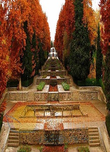
Kangavar is located to the east of the province and near the province of Hamadan. The same has a temperate mountainous climate. It is one of the historical towns of the country due to the Anahita Temple. This city was flourishing till the Sassanide period, but after the Arab aggression on Iran, was destroyed. At present the relics of the Anahita Temple is within the city. This temple was built from stone and has sculptured stone columns. Arab historians and geographers after the 4th century AH. have mentioned this region. Kangavar was reputed in the Islamic period and at present is reputed for its Anahita Temple (palace). The distance between Kangavar and Tehran is 616 km.
Kermanshah
The city of Kermanshah is located in the center of the province and has a temperate climate. Kermanshah is one of the ancient cities of Iran and it is said that, Tahmores Divband, a mythical ruler of the Pishdadian had constructed it. Some attribute its constructions to Bahram Sassanid. During the reign of Qobad I and Anushirvan Sassanid, Kermanshah was at the peak of its glory. But in the Arab attack suffered great damage. Concurrent with the Afghan attack and the fall of Esfahan, Kermanshah was destroyed due to the Ottoman invasion. But from the beginning of the 11th century AH. it began to flourish.
In order to prevent a probable aggression of the Zangeneh tribe and due to its proximity with Ottoman Empire, the Safavid ruler paid great attention to this city. But in the Zandieh period upheavals increased, whereas during the Qajar era, Ottoman attacks reduced. Mohammad Ali Mirza in 1221 AH. was seated in kermanshah in order to prevent Ottoman aggression, and Khuzestan also came under his realm. An epigraph of Mohammad Ali Mirza in Taq-e-Bostan has been remained as a relic.
In 1267 AH. Imam Qoli Mirza was appointed by Naseredin Shah to protect the Kermanshah frontier. The former during his rule of 25 years constructed some buildings which have remained to be seen. In the Constitutional Movement this city played an important role and in World War I and II and was taken possession by foreign powers and after the war ended, the city was evacuated. As a result of the imposed Iraq war, this city sustained great losses and after the war vast efforts were taken to rehabilitate it. Kermanshah is the capital of the Kermanshah province and is located at a distance of 526 km. from Tehran.
Paveh (Oramanat)
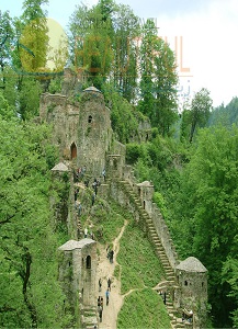
Paveh is located in the Oramanat Mountainous region and to the extreme northwest of the province. From the west it is limited to Iraq. Paveh has cold winters and temperate summers. The small mountainous city of Paveh is to the northwest of Kermanshah and located at a distance of 636 km. from Tehran. The name of Paveh is attributed to Paveh, one of the commanders of Yazdgerd III, who in order to seek the Kurd support settled in this region and was extremely respected by the people of this territory. The Dej and Pasgah forts which have remained since then are the relics of that era. The word Oramanat is derived from the word Uortan or Uorman and related to sacred Zoroastrian anthems.
Qasr-e-Shirin
Qasr-e-Shirin lies at a distance of 692 km. from Tehran, and is located to the northwest of Kermanshah. The climate of this city is warm and from this point of view it is distinctive from the other townships of the province. Qasr-e-Shirin is one of the ancient cities of Iran related to the Khosrow Parviz era. It was thriving during the Achaemenian period. Around the present city the ruins of the ancient Qasr-e-Shirin, has been remained together with a collection of demolished stone and walls. It is said that during the rule of Khosrow Parviz there was a large garden with beautiful palaces. Out of which the most famous were Khosrow and Shirin Palaces.
Qasr-e-Shirin till 1270 AH. was a small town. But in the World War I became the border town for the German and Ottoman soldiers from one hand and for English and Russian soldiers on the other hand. During the Iran-Iraq war Qasr-e-Shirin was demolished, but after the conclusion of the war it was renovated. Now this city has expanded and has changed to attractive and large area.
Sahneh
Sahneh is located to the east of Kermanshah and has mountainous and temperate climate. The region of Sahneh was a part of the province but in recent years has been changed to an independent township. The limits of this region is one of the old and historical zones of this province and holds vestiges and monuments of the past periods. Sahneh is located en route of Kermanshah - Tehran Road and is at a distance of 586 km. from Tehran.
Sar Pol-e-Zahab
The township of Sar Pol-e-Zahab is located in the west of the province and is limited to Iraq from its western borders. Its climate is warm but in some parts temperate. This city is located at the distance of 665 km. from Tehran. Sar Pol-e-Zahab is near the ruins of the ancient city of Halvan and a ruined castle can be also seen near the same.
Sar Pol-e-Zahab was considered as a castle and frontier base of Iran, which was destroyed in the Arab invasion to Iran, and only some remnants of its brick laid pillars have remained. In historical books it has been mentioned as the center of Halvan state. The name of "Sar Pol" has been taken from a bridge on Alvandoo River and the suffix of "Zahab" was due to the abundance of springs and wetlands. This city with its natural attractions sustained losses in the imposed war but after the conclusion of the war it was renovated.
Sonqor
The township of Sonqor is located in the northeast of Kermanshah and has a mountainous and temperate climate. The same is at a distance of 612 km. from Tehran. The word Sonqor means a hunting bird. In the Saljuqi period the commanders of Sonqor were known as Aqa Sonqor. During the reign of Shah Esmail Safavieh II, Sonqor was under the rule of "Soulaq Hossain Taklou". During the reign of Shah Tahmasb I, a rule of Sonqor and Kalhor was established in this territory and was given to the Zangeneh tribal chiefs. In the Afshariyeh and Zandieh reigns the rule of Sonqor was given to the chiefs of the Kalyaie tribes and then after "Khosow Khan Ardalan", governor of Kurdestan was appointed as ruler of this city.
During the rule of Fathali Shah Qajar, his son Fathollah Mirza was appointed as a governor of Sonqor. This area was then merged with Kangavar, Malayer and Towiserkan and brought under the rule of Sheikhali Mirza, the son of Fathali Shah. At present Sonqor and Koliaee are attractive and beautiful regions of Kermanshah which are placed in a level and beautiful plain alongside a river, with beautiful gardens and groves surrounding it, thereby increasing its values regarding tourism.
Inscriptions and Engravings, Kermanshah
Anubanini Inscription, Sar Pol-e-Zahab
In the vicinity of Sar Pol-e-Zahab, there is an Anubanini impression engraved in the breast of a rock. The same is alongside an inscription written in Akadi script and this relic is present even up to this date. The two embossments of this rock are related to 2800 years BC., engraved in the breast of the a mountain reaching an elevation of 35 m. high., and it is attributed to Semitic monarch known as "Anubanini". The left foot of this impression has been put on a captive. Under this engraving the faces of 16 other captives under tragic conditions have been displayed. An inscription revealing the victory of Anubanini can also be observed below the said effect.
Arsacidian Goodarz the 2nd Inscription, Bistoon
To the east of the Miteridat embossment, on the same rock, is the engraving of one of his successors named as, Goodarz II (46-51 AD.). This Impression depicts the victory of Goodarz II on his rival Mehrdad, and also shows the presence of two riders armed with spears. In the hand of an angel is a wreath of flowers, which is a sign of victory. Behind Goodarz, is the engraving of one of his relatives. An archaic Greek inscription has mentioned the names of these two monarchs. Today only the name of Goodarz can be noted, as the other parts of the said inscription has been demolished.
Bistoon Inscription, Bistoon
The primary scientific studies regarding the engravements and inscriptions of Bistoon were made in 1835, by Henry Rawlinson, a young British officer. After which this research was carried on by several scientists who added their discoveries to this historical treasure. The text of this inscription was engraved in the breast of the mountain in 522 BC. by a decree from Dariush. The same relates to the war which lasted for two and a half years, between him and his opponents in order to gain power.
Encircling the Bistoon impression is an epigraph in three languages, named as, the ancient Parsi, Elamite and a Babylonian dialect. The Elamite text is to the right of the impression, the second to the left, running parallel to the Parsi text. Whereas, the Babylonian text stands above that of the second Elamite inscription. Additional and complete translations can be observed in the surroundings and to the right.
The ancient Parsi text is in 414 lines and engraved in a beautiful uniform script on a polished surface. In all the epigraphs of Dariush the Achaemenian begins with the phrase "King Dariush proclaims" and this is repeated throughout his decrees, emphasizing the grandeur and greatness of the power of this monarch. This sovereign owned his victory to Ahura Mazda and thus offered a religious effect to the epigraph to a great extent. This view can be noted and brought to light specially in the fourth column of the inscription.
Dariush Inscriptions, Bistoon Rock
The above mentioned is an embossment on a rock, and the main feature depicted here is that of Dariush (Dariush). The monarch has a scalloped crown on the head, and his left foot rests on the chest of Geomat. Behind him are two bodyguards. Above the head of Dariush is the image of Farvahar in flight. Farvahar carries a circular band in the left hand, which is the sign of sovereignty. The same is offered as a token to Dariush. Facing Dariush are 90 rebels (of jurisdictions under the power of the sovereign).
These rebels have harnesses around the neck and their hands are tied. This epigraph of Dariush in the Bistoon mountains, alike others of the Achaemenian period, reveal the influence of the Babylonians and Assyrians art in the Achaemenian civilization.
Dokan Davood Inscription, Sar Pol-e-Zahab
The above mentioned is a crypt in the breast of a mountain, and is located 3 km. to the south east of Sar Pol-e-Zahab. This engraving reveals the face of a man, with a date leaf in his hands, probably in a state of worship. This crypt and its epigraph is related to the Medes.
Faratash (Farhad Tarash) Inscription, Bistoon
To the south of the engraving of Dariush the Great, in the Bistoon Mountains, is a gigantic engraved rampart or wall, reputedly known as Faratash and Takht-e-Farhad by the inhabitants. It is said that the same was engraved by a decree issued by Khosrow Sassanide II approximately a millennium after the reign of Dariush. The inhabitants of this vicinity believe that the above mentioned engravings belong to Farhad (the sculpture or stone culture in this mountain).
This episode relates to a love story related to Shirin (the spouse of Khosrow Parviz) and Farhad. Needless to say, this theme is a pronounced one in many of the poems of the country. Nezami Ganjavi, the great poet being one of the prominent. The length of the Faratash rampart is 180 m. and it must be brought to attention that no where else in Iran or on its mountains, such a colossal engraving exists.
Herkool Statue, Bistoon
Alongside the Bistoon - Kermanshah Road, is an embossment of a heroic figure leaning against a piece of lion skin. This embossment shows a completely naked and powerful man with curly hair and beard. He is leaning on his left side under the shelter of a tree. To its left hand side a cup is seen. In this impression, the right hand of the figure is placed on the right foot, whereas the left foot leans on the right one. The length of this statue is 147 cm. Behind the said statue, inscriptions and images can be observed in the ancient Latin or Greek script.
The same is very similar to that of the Grecian temples an impression alongside the inscription reveals a tree with a double pointed bow hanging on a branch, besides an archers sheath or quiver full of arrows also hanging from a branch of the tree. On the two sides of the platform on which the statue is located, a rampart of stone can be observed. The same is of non-sculptured stone and covered with gypsum.
Pahlavi Script Inscriptions, Bistoon
Throughout Bistoon and its surroundings, wherever a sculptured stone or structure is present, scripts dating to the Sassanide era can be noted. Such as the 427 symbols engraved on stones in vicinities like the Safavid caravansary of Bistoon, the Safavid bridge on Dinvar Ab, the Khosravi bridge on Garmasiab, the caravansary edifice of Bistoon and the engravings on the rocks scattered in various sections of Bistoon. These symbols are similar to that of households, names of certain personalities, on even workshops (foundries) who were responsible for these sculptured effects.
Parthian Miteridant Inscription, Bistoon
Under the Achaemanian inscription of Bistoon, is the archaic embossment of the Parthian that has come to light to date. The same is an engraving of 100 years BC. The same has come to reveal that the Parthian ruler of the time, selected the location of this impression in such a manner so as to make a distinct mark between the Parthian and the Achaemenian eras. As regards artistic measures, the said shows no sign of movement or technique, the latter is moreover primary. Those who are named in this inscription are recorded in the Latin or Greek script.
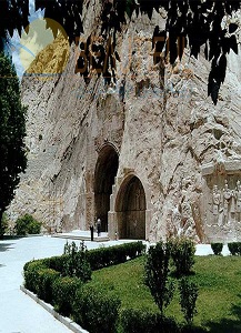
Taq-e-Bostan Engraving, Kermanshah
The "Taq-e-Bostan" (Bostan Arch) or "Taq-e-Vostan" (Vostan Arch) is situated to the right of the city entrance of Kermanshah, and is to the north east of this city. This aggregate which comprises of engravings and epigraphs is related to the Sassanide era. The same is located in the mountain, and together with the natural surroundings, a gorgeous landscape comes into view. On entering this area, the first epigraph is related to Ardeshir II. Ardeshir stands between Ahoura Mazda and Mitra. His face turned towards Ahoura Mazda, and his left hand receiving a wreath of friendship from Ahoura Mazda. Under their feet lies the enemy or "Ahriman".
After this epigraph there is a smaller arch, which depicts the figures of Shapour II and his son Shapour III, and above each of these impression the personalities of epigraph have been introduced in Pahlavi Sassanide script. In the third section of this aggregate there are beautiful epigraphs throughout, revealing winged angels, the tree of life, boar hunting in the groves, duck hunting etc.… together with a group of musicians bringing about a festive atmosphere.
Below the epigraph is an armed rider on a horse. Some believe this to be "Pirouz Sassanid", whilst others take this personality to be "Khosrow Parviz"
Other Engravings and Inscriptions, Kermanshah
Small Bistoon inscriptions, no. 1 Bistoon inscription (related to primary Islamic centuries), no. 2 Bistoon inscription placed in the old caravansary of Bistoon (related to 3rd and 4th centuries AH.), no. 3 Bistoon inscription on sculptured stones in old Bistoon caravansary's wall, a piece of limestone and a lion stone in Bistoon (related to the 2nd milllenium BC.), the Parthian Valgash Inscription on the skirts of the Bistoon Mountains (related to he Parthian era), an engraved platform a rock in Bistoon (of the Parthian age), an inscription pertaining to the endowments of Sheikh Ali Khan Zanganeh on Bistoon rock (related to Safavid era), and the Gerech Arch in Islam Abad Qarb (related to the Sassanide period)
Temples and Fire Temples, Kermanshah
Anahita Temple, Kangavar
In Kangavar, on an elevated rocky platform, is the remnants of a majestic structure. The same belongs to the pre-Islamic era and was known as Anahita. The name of this temple is depicted from Anahita (Nahid) who was a deity and gaurd angel of water, abundance and blessing. Some believe that the structure dates back to the Parthian era, whilst upon this relic the evidences of this period and the early Islamic era can also be noted. According to scientific researches, the architectural characteristics of this temple have acquired inspiration from that of the Achaemenian age.
The main structure of the Anahita temple is a quadrilateral one. Its ramparts being 230 m. in length, and its thickness in most of the parts is 18 m. which reveals the archaic grandeur and magnificence of this structure. The stairway of the temple is bilateral and closely attached to the wall. The difference between the lowest and highest point of the structure is 30 m. and is in a form of steps, similar to the Achaemenian structures. At the foot of the eastern wall of the structure is a cemetery which is related to the Parthian era. It is noted that the deceased have been buried in such a way to face the Anahita structure.
Chahar Qapoo Fire Temple, Qasr-e-Shirin
The same is a historical monument of the Sassanide era in Qasr-e-Shirin. It was constructed of stone and gypsum and was counted as one of the largest fire temples of the Sassanid period. The fire temple has a square shaped chamber in the center with a domed ceiling, which closely resembles the other fire temples of the period. The width of the main opening of this fire temple is over 16m.
Goor Dakhmeh Darband, Sonqor
This large rectangular shaped crypt is a historical remnant in the city of Sonqor, from the times of the Meads. The outstanding features of the same are its impression and guide lines of Ahoura Mazda, that is a sun with wings displayed on the facade of the crypt.
Parthian Temple, Bistoon
To the north of the Dariush engraving in Bistoon, are the remnants of a structure from the Parthian period. The same is a temple or a worshiping site built during the Parthian period, coinciding with the construction of another relic in Bistoon. This Parthian temple which is situated opposite the slab of Parthian impressions, comprises of two platforms. These platforms are connected to each other by 10 steps, which run irregularly right up to the Valgash inscription. On the upper platform is a sculptured brazier of stone. Evidences of earthenware of the Parthian era are noted in the surrounding skirts of the Bistoon Mountain.
Other Fire Temples, Kermanshah
The other fire temples of the province are as follows: Kaikavoos rock tomb in north Sahneh, related to the Medes and the Medes platform in Bistoon related to the first millennium BC.